  • Facebook
  • Instagram
  • Twitter
  • Linkedin
  • Youtube
  • ASK US
Home South Florida Water Management District
  • Who We Are
    • Governing Board Chairman
    • Open Government
    • Governing Board
    • Budget & Finance Reports
    • Careers
    • Locations
    • Contact Us
  • Our Work
    • Flood Control
    • Water Supply Planning
    • Water Quality Improvement
    • Ecosystem Restoration
    • Python Elimination Program
    • Addressing Blue-Green Algae
    • Resiliency
  • Doing Business with Us
    • Permits
    • RegPermitting
    • ePermitting
    • Right of Way Permits
    • Procurement
    • Real Estate
    • Grants/Funding Opportunities
  • Community & Residents
    • Water Conservation
    • Recreation
    • Navigation
    • Education Center
    • Everglades License Plate
  • Science & Data
    • Real-Time Data
    • Vertical Datum Upgrade
    • Scientific Publications & SFER
    • DBHYDRO
    • Weather
    • Operational Planning
    • GIS
    • Survey Data
    • Modeling
  • News & Meetings
    • News Releases
    • Public Meetings
    • Calendar
    • Speakers Bureau
    • Media, Photo & Video
    • Fact Sheets
  • Contact Us
  • Careers
  • Locations
  1. Home
  2. our work
  3. c100a canal
  • Flood Control
    • Overview
    • Emergency Management
    • Keeping Canal Right of Way Clear
    • Flood Protection Level of Service
  • Water Supply Planning
    • Overview
    • Upper Kissimmee Basin (CFWI) Plan
    • Lower Kissimmee Basin Plan
    • Upper East Coast Plan
    • Lower East Coast Plan
    • Lower West Coast Plan
    • Alternative Water Supply
    • Water Supply Facilities Work Plans
  • Water Quality Improvement
    • Overview
    • Restoration Strategies
    • Long-Term Plan
    • Everglades Technical Oversight Committee
  • Ecosystem Restoration - By Region
    • Overview
    • Everglades
    • Kissimmee River
    • Lake Okeechobee
    • Coastal Watersheds
    • Florida Bay
  • Ecosystem Restoration - Projects and Programs
    • Advancing Key Priority Projects
    • Biscayne Bay Economic Impact Study
    • CERP Project Planning
    • CERP Funding and Implementation
    • EAA Storage Reservoir Project
    • Feeder Canal Basin Water Quality Program
    • Lake Okeechobee Watershed Restoration Project
    • Lake Okeechobee Component A Reservoir (LOCAR)
    • Lower Kissimmee Basin Stormwater Treatment Area
    • Northern Everglades and Estuaries Protection Program
    • Picayune Strand Restoration Project
    • Water Storage Strategies
  • MFLs & Water Reservations, & RAAs
    • Minimum Flows & Minimum Water Levels
    • Water Reservations
    • Restricted Allocation Areas
  • Land Management
    • Overview
    • Vegetation and Exotic Control
    • Python Elimination Program
    • Land Assessment
  • Local Projects and Programs
    • C-100A Canal Vegetation Removal Project
    • C-15 Canal Vegetation Removal Project
    • Cocohatchee Canal I-75 Loop Interchange Tree Removal Project
    • Corkscrew Watershed Initiative Public Planning Project
    • Flood Protection Around Henderson Creek Canal
    • Lake Belt Mitigation Committee
  • Addressing Blue-Green Algae
  • Resiliency
    • Overview
    • Resiliency and Flood Protection
    • Resiliency and Water Supply
    • Resiliency and Ecosystem Restoration
    • Water and Climate Resilience Metrics
    • Central and Southern Florida Flood Resiliency Study
    • Sea Level Rise and Flood Resiliency Plan
    • Resiliency Coordination Forum

C-100A Canal Vegetation Removal Project

The fifth phase of tree removal along canal easements in Palmetto Bay is planned to start in February 2020. Details below.

Click for before and after photos of Phase 1To ensure a 7-mile section of the C-100A Canal can continue to provide adequate flood protection for residents in the Villages of Pinecrest and Palmetto Bay, the South Florida Water Management District is conducting a phased tree removal effort. A total of seven, 1-mile phases will be completed.

To access and maintain the canal banks to provide optimal flood protection, the District has right-of-way easements along the canal situated on private property in Pinecrest and Palmetto Bay. Some residents have installed or constructed improvements (i.e., fences, docks, gazebos) within the easement. Residents are advised that some of these improvements may need to be removed prior to the removal of trees on a homeowner's property to allow the project to proceed. Thereafter, reinstallation of certain improvements within the District’s easement may not be permitted, as they may become obstructions during heavy rainfall, blocking drainage and causing flooding, as well as interfering with emergency flooding response.
 

Tree Removal Areas and Schedule

All impacted residents will be notified 30 days from the start date and again two weeks prior to the commencement of work in a specific area. District staff will continue to update residents impacted by the project until all work is complete. This web page will also be updated regularly with canal closures, property access details and project status updates.

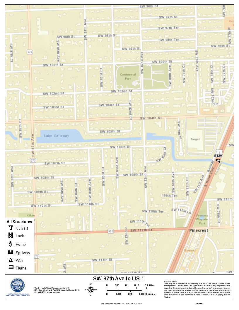
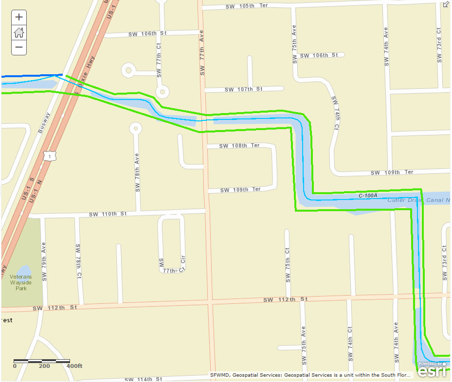
  • PHASE 5 – Winter 2020: The fifth phase consists of a section in unincorporated Miami-Dade County west from U.S. 1 to SW 87th Ave. The work will begin in February 2020 and is expected to be completed within three months.
    MAP: Phase 5 [PNG] • Legal Surveys [PDF]
     
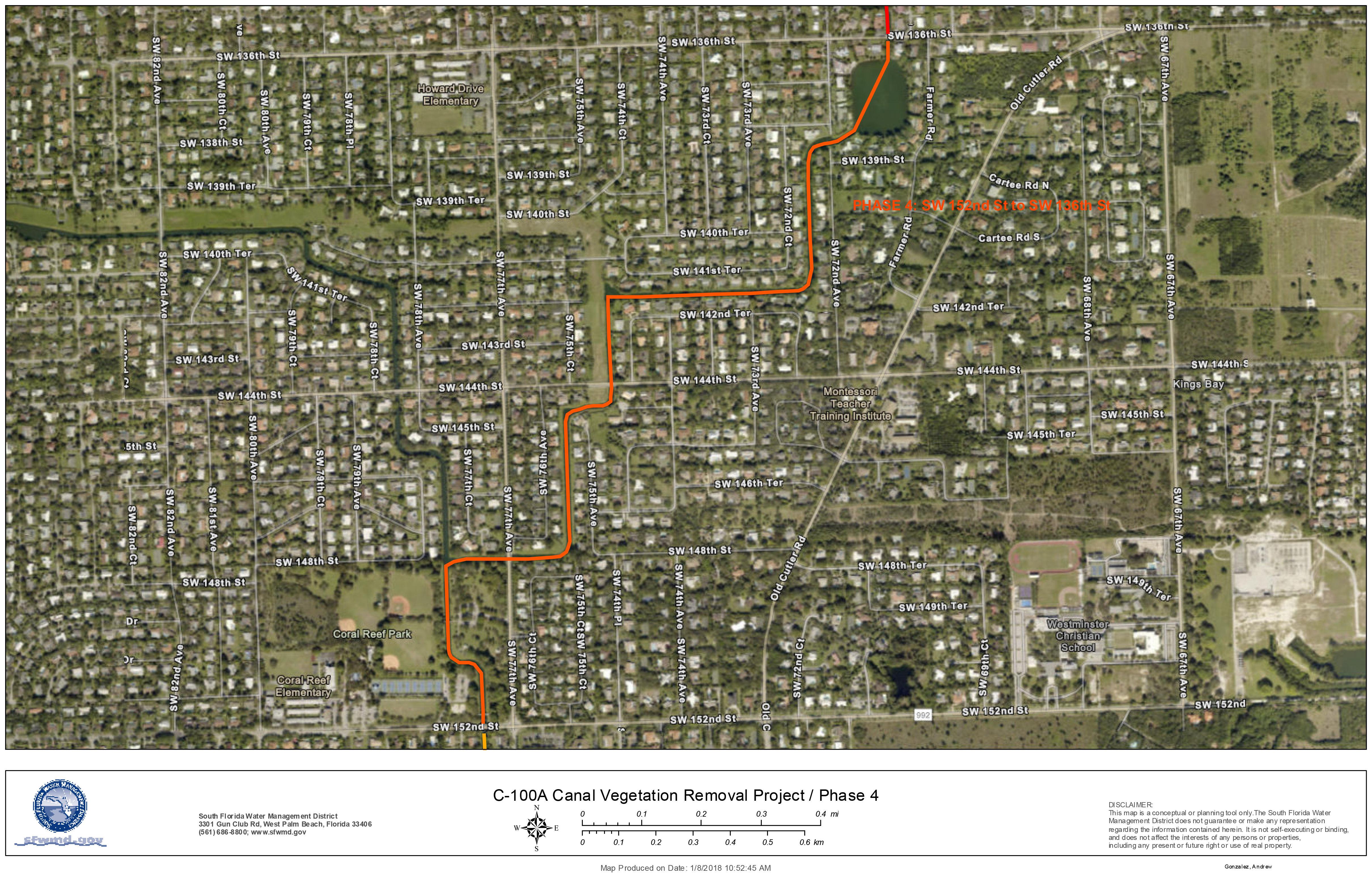
  • PHASE 4 – Winter 2019: The fourth phase is 1.6 miles from 136th Street south to 152nd Street in the Village of Palmetto Bay is planned to begin in January 2019. The work is expected to be completed within three months.
    MAP: Phase 4 [PNG] • Legal Surveys [PDF]
     
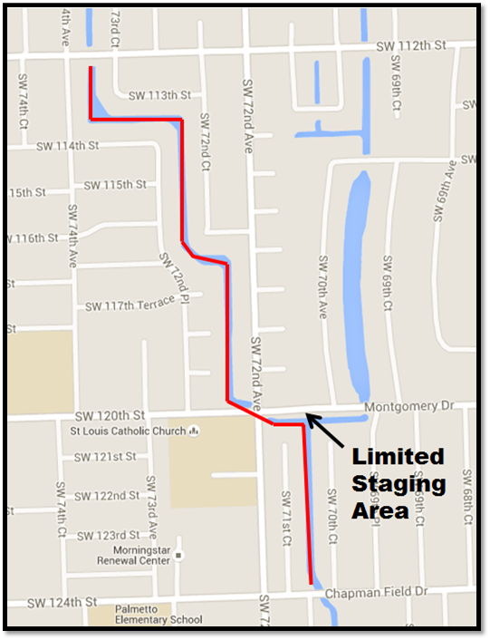
  • PHASE 3 – Fall 2017: The third phase consisted of a section from U.S. 1 to Killian Drive (SW 112th Street) in the Village of Pinecrest. The work was completed in February 2018.
    MAP: Phase 3 [PNG] • Legal Surveys [PDF]
     
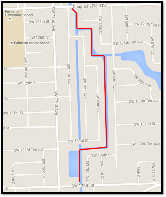
  • PHASE 2 – Summer 2017: The second phase consisted of a 1-mile section from SW 112th Avenue (Killian Drive) to SW 124th Street (Chapman Field). The work was completed in October 2017, and this section of canal is now passable to boat traffic again.
    MAP: Phase 2 [PNG] • Legal Surveys [PDF]
     
  • PHASE 1 – Winter 2017: The first phase consisted of a 1-mile section from SW 124th Street (Chapman Field) to SW 136th Street (Howard Drive). The work was completed in April 2017, and this section of canal is now passable to boat traffic again.
    MAP: Phase 1 [PNG] • Legal Surveys [PDF]

SIGN UP FOR UPDATES – Get the latest on the project
 

For More Information

  • Click for project overviewOVERVIEW PRESENTATION: C-100A Canal Flood Control Project [PDF]
  • FIRST LETTER OF NOTICE: Letter to residents – Oct. 11, 2016 [PDF]
  • SECOND LETTER OF NOTICE: Letter to residents – Dec. 14, 2016 [PDF]
  • FACT SHEET: FYI: C-100 Series of Canal Maintenance [PDF]
  • NEWS RELEASE: SFWMD Clearing Effort Helps Ensure the Safety of South Miami-Dade County Families – Feb. 2, 2017
  • FAQs: Canal right-of-way permits [PDF]
  • FACT SHEET: Keeping Canals Clear: How you can help [PDF]
  • INFOGRAPHIC: Rain Drain: What to expect in your neighborhood when it rains [PDF]
  • CONTACT:
    Armando Vilaboy, SFWMD Regional Representative
    (305) 513-3420, Ext. 7249

SFWMD maintains more than 2,000 miles of canals from Orlando to the Florida Keys. Keeping them clear of debris and vegetation, especially on their banks, ensures the regional flood control system works to protect Florida families and businesses.

×

MAP: C-100A Canal Vegetation Removal Project – Phase 1

MAP: C-100A Canal Vegetation Removal Project - Phase 1

Close
×

MAP: C-100A Canal Vegetation Removal Project – Phase 2

MAP: C-100A Canal Vegetation Removal Project - Phase 2

Close
×

MAP: C-100A Canal Vegetation Removal Project – Phase 3

MAP: C-100A Canal Vegetation Removal Project - Phase 3

Close
×

MAP: C-100A Canal Vegetation Removal Project – Phase 4

MAP: C-100A Canal Vegetation Removal Project - Phase 4

Close
×

MAP: C-100A Canal Vegetation Removal Project – Phase 5

map of phase 5


Close
  • ASK US
  • Who We Are
    • Governing Board
    • Big Cypress Basin Board
    • Open Government
    • Public Records Request
  • Our Work
    • Flood Control
    • Resiliency
    • Emergency Management
    • Water Supply Planning
    • Water Quality Improvement
    • Ecosystem Restoration
    • Land Management
  • Community and Residents
    • Water Conservation
    • Year-Round Rule
    • Recreation
    • Educational Center
    • Volunteering
  • Doing Business with Us
    • Permits
    • RegPermitting
    • ePermitting
    • Right of Way Permits
    • Procurement
    • Real Estate
    • Grants/Funding
    • Agriculture
    • AVATAR
  • Science and Information/Data
    • Real-Time Data
    • Water Levels
    • Scientific Publications & SFER
    • DBHYDRO
    • Weather
    • Operational Planning
    • Environmental Monitoring
    • Modeling
  • News and Events
    • News Releases
    • Meeting Agendas & Minutes
    • Calendar
    • Photo and Video Resources
South Florida Water Management District

Contact Information

3301 Gun Club Road
West Palm Beach, FL 33406

561-686-8800

800-432-2045 (Florida Only)

  • Facebook
  • Instagram
  • Twitter
  • Linkedin
  • Youtube
  • ASK US
  • Privacy Policy
  • Disclaimer
  • Accessibility
  • Contact Us
  • Locations
  • Careers