  • Facebook
  • Instagram
  • Twitter
  • Linkedin
  • Youtube
  • ASK US
Home South Florida Water Management District
  • Who We Are
    • Governing Board Chairman
    • Open Government
    • Governing Board
    • Budget & Finance Reports
    • Careers
    • Locations
    • Contact Us
  • Our Work
    • Flood Control
    • Water Supply Planning
    • Water Quality Improvement
    • Ecosystem Restoration
    • Python Elimination Program
    • Addressing Blue-Green Algae
    • Resiliency
  • Doing Business with Us
    • Permits
    • RegPermitting
    • ePermitting
    • Right of Way Permits
    • Procurement
    • Real Estate
    • Grants/Funding Opportunities
  • Community & Residents
    • Water Conservation
    • Recreation
    • Navigation
    • Education Center
    • Everglades License Plate
  • Science & Data
    • Real-Time Data
    • Vertical Datum Upgrade
    • Scientific Publications & SFER
    • DBHYDRO
    • Weather
    • Operational Planning
    • GIS
    • Survey Data
    • Modeling
  • News & Meetings
    • News Releases
    • Public Meetings
    • Calendar
    • Speakers Bureau
    • Media, Photo & Video
    • Fact Sheets
  • Contact Us
  • Careers
  • Locations
  1. Home
  2. our work
  3. land assessment
  • Flood Control
    • Overview
    • Emergency Management
    • Keeping Canal Right of Way Clear
    • Flood Protection Level of Service
  • Water Supply Planning
    • Overview
    • Upper Kissimmee Basin (CFWI) Plan
    • Lower Kissimmee Basin Plan
    • Upper East Coast Plan
    • Lower East Coast Plan
    • Lower West Coast Plan
    • Alternative Water Supply
    • Water Supply Facilities Work Plans
  • Water Quality Improvement
    • Overview
    • Restoration Strategies
    • Long-Term Plan
    • Everglades Technical Oversight Committee
  • Ecosystem Restoration - By Region
    • Overview
    • Everglades
    • Kissimmee River
    • Lake Okeechobee
    • Coastal Watersheds
    • Florida Bay
  • Ecosystem Restoration - Projects and Programs
    • Advancing Key Priority Projects
    • Biscayne Bay Economic Impact Study
    • CERP Project Planning
    • CERP Funding and Implementation
    • EAA Storage Reservoir Project
    • Feeder Canal Basin Water Quality Program
    • Lake Okeechobee Watershed Restoration Project
    • Lake Okeechobee Component A Reservoir (LOCAR)
    • Lower Kissimmee Basin Stormwater Treatment Area
    • Northern Everglades and Estuaries Protection Program
    • Picayune Strand Restoration Project
    • Water Storage Strategies
  • MFLs & Water Reservations, & RAAs
    • Minimum Flows & Minimum Water Levels
    • Water Reservations
    • Restricted Allocation Areas
  • Land Management
    • Overview
    • Vegetation and Exotic Control
    • Python Elimination Program
    • Land Assessment
  • Local Projects and Programs
    • C-100A Canal Vegetation Removal Project
    • C-15 Canal Vegetation Removal Project
    • Cocohatchee Canal I-75 Loop Interchange Tree Removal Project
    • Corkscrew Watershed Initiative Public Planning Project
    • Flood Protection Around Henderson Creek Canal
    • Lake Belt Mitigation Committee
  • Addressing Blue-Green Algae
  • Resiliency
    • Overview
    • Resiliency and Flood Protection
    • Resiliency and Water Supply
    • Resiliency and Ecosystem Restoration
    • Water and Climate Resilience Metrics
    • Central and Southern Florida Flood Resiliency Study
    • Sea Level Rise and Flood Resiliency Plan
    • Resiliency Coordination Forum

Land Assessment

Over six decades, the South Florida Water Management District has acquired nearly 1.5 million acres of land within its 16-county jurisdiction to support flood control infrastructure, protect water resources and restore impaired ecosystems. As part of a broad effort to maximize its resources to meet mission-critical responsibilities, the District is conducting a comprehensive land assessment to ensure that each parcel is being put to its most effective use.

Results of First Phase and Next Steps
thumbnail for list of properties recommended for surplus or exchangeCompleted in September 2013, the first phase of the SFWMD land assessment was a review of fee-owned lands – approximately 750,000 acres in which the agency has full or shared ownership rights.

As a result of the assessment process, some properties were recommended for potential exchange or surplus. Following further evaluation by SFWMD staff, final recommendations on exchange or surplus of these lands are being presented to the Governing Board throughout the year.

For more information, see:

  • Surplus Land
  • Surplus Lands Database
     

Land Assessment Materials by Region

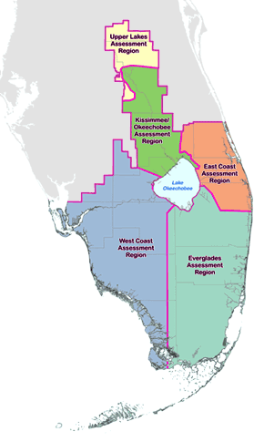
For the first phase of the land assessment process, the 16-county District was divided into five geographic regions. Posted below for each region are detailed land portfolios, summaries of comments from the public and SFWMD subject matter experts and staff recommendations.

Upper Lakes Assessment Region Kissimmee/Okeechobee Assessment Region West Coast Assessment Region East Coast Assessment Region Everglades Assessment Region

map of land assessment regions

Upper Lakes Assessment Region*
  • Summary of Recommendations [PDF]
  • Detailed Recommendations [PDF]
  • Public and Subject Matter Expert Comments
  • Region Overview [PDF]
  • Land Portfolio
Kissimmee/Okeechobee Assessment Region
  • Summary of Recommendations [PDF]
  • Detailed Recommendations [PDF]
  • Public and Subject Matter Expert Comments
  • Region Overview [PDF]
  • Land Portfolio
East Coast Assessment Region*
  • Summary of Recommendations [PDF]
  • Detailed Recommendations [PDF]
  • Public and Subject Matter Expert Comments
  • Region Overview [PDF]
  • Land Portfolio
West Coast Assessment Region
  • Summary of Recommendations [PDF]
  • Detailed Recommendations [PDF]
  • Public and Subject Matter Expert Comments
  • Region Overview [PDF]
  • Land Portfolio
Everglades Assessment Region*
  • Summary of Recommendations [PDF]
  • Detailed Recommendations [PDF]
  • Public and Subject Matter Expert Comments
  • Region Overview [PDF]
  • Land Portfolio
Fee-Owned Properties Recommended for Further Evaluation for Potential Exchange or Surplus [PDF]

 
* NOTE: Due to a variety of assessment challenges, the Munger Tract (Upper Lakes), Pal-Mar Area (East Coast) and Bird Drive Basin (Everglades) will be analyzed separately from other SFWMD lands in their respective regions. Learn more »


Objectives and Evaluation Criteria

The first phase of the land assessment process thoroughly analyzed each parcel of SFWMD fee-owned land to determine how its current use contributes to the agency's core mission of balancing and improving flood control, water supply, water quality and natural systems. Staff recommended that land uses remain in place for parcels that were determined to contribute fully to the core mission. To provide the most benefit to taxpayers, lands that were determined to not directly support the core mission were considered for alternative uses or recommended to the SFWMD Governing Board for possible surplus.

The District utilized a variety of criteria to evaluate its fee-owned lands, including:

  • Analyzing statewide and SFWMD-specific geographic information system (GIS) mapping layers to identify each parcel's environmental value and its value related to water resource management
  • Examining the intended uses of the parcels when they were acquired
  • Soliciting input from SFWMD subject matter experts with direct knowledge of individual lands
  • Receiving feedback and recommendations from stakeholders, nearby landowners, local governments and members of the public

As part of a commitment to transparency and public involvement, the public could review detailed regional land portfolios and submit comments on specific properties on this web page. Regional workshops were held to gather further public input.

  • 2013 SFWMD Land Assessment Study Process – Fee-Simple Lands [PDF]


  • ASK US
  • Who We Are
    • Governing Board
    • Big Cypress Basin Board
    • Open Government
    • Public Records Request
  • Our Work
    • Flood Control
    • Resiliency
    • Emergency Management
    • Water Supply Planning
    • Water Quality Improvement
    • Ecosystem Restoration
    • Land Management
  • Community and Residents
    • Water Conservation
    • Year-Round Rule
    • Recreation
    • Educational Center
    • Volunteering
  • Doing Business with Us
    • Permits
    • RegPermitting
    • ePermitting
    • Right of Way Permits
    • Procurement
    • Real Estate
    • Grants/Funding
    • Agriculture
    • AVATAR
  • Science and Information/Data
    • Real-Time Data
    • Water Levels
    • Scientific Publications & SFER
    • DBHYDRO
    • Weather
    • Operational Planning
    • Environmental Monitoring
    • Modeling
  • News and Events
    • News Releases
    • Meeting Agendas & Minutes
    • Calendar
    • Photo and Video Resources
South Florida Water Management District

Contact Information

3301 Gun Club Road
West Palm Beach, FL 33406

561-686-8800

800-432-2045 (Florida Only)

  • Facebook
  • Instagram
  • Twitter
  • Linkedin
  • Youtube
  • ASK US
  • Privacy Policy
  • Disclaimer
  • Accessibility
  • Contact Us
  • Locations
  • Careers