  • Facebook
  • Instagram
  • Twitter
  • Linkedin
  • Youtube
  • ASK US
Home South Florida Water Management District
  • Who We Are
    • Governing Board Chairman
    • Open Government
    • Governing Board
    • Budget & Finance Reports
    • Careers
    • Locations
    • Contact Us
  • Our Work
    • Flood Control
    • Water Supply Planning
    • Water Quality Improvement
    • Ecosystem Restoration
    • Python Elimination Program
    • Addressing Blue-Green Algae
    • Resiliency
  • Doing Business with Us
    • Permits
    • RegPermitting
    • ePermitting
    • Right of Way Permits
    • Procurement
    • Real Estate
    • Grants/Funding Opportunities
  • Community & Residents
    • Water Conservation
    • Recreation
    • Navigation
    • Education Center
    • Everglades License Plate
  • Science & Data
    • Real-Time Data
    • Vertical Datum Upgrade
    • Scientific Publications & SFER
    • DBHYDRO
    • Weather
    • Operational Planning
    • GIS
    • Survey Data
    • Modeling
  • News & Meetings
    • News Releases
    • Public Meetings
    • Calendar
    • Speakers Bureau
    • Media, Photo & Video
    • Fact Sheets
  • Contact Us
  • Careers
  • Locations
  1. Home
  2. our work
  3. florida bay
  • Flood Control
    • Overview
    • Emergency Management
    • Keeping Canal Right of Way Clear
    • Flood Protection Level of Service
  • Water Supply Planning
    • Overview
    • Upper Kissimmee Basin (CFWI) Plan
    • Lower Kissimmee Basin Plan
    • Upper East Coast Plan
    • Lower East Coast Plan
    • Lower West Coast Plan
    • Alternative Water Supply
    • Water Supply Facilities Work Plans
  • Water Quality Improvement
    • Overview
    • Restoration Strategies
    • Long-Term Plan
    • Everglades Technical Oversight Committee
  • Ecosystem Restoration - By Region
    • Overview
    • Everglades
    • Kissimmee River
    • Lake Okeechobee
    • Coastal Watersheds
    • Florida Bay
  • Ecosystem Restoration - Projects and Programs
    • Advancing Key Priority Projects
    • Biscayne Bay Economic Impact Study
    • CERP Project Planning
    • CERP Funding and Implementation
    • EAA Storage Reservoir Project
    • Feeder Canal Basin Water Quality Program
    • Lake Okeechobee Watershed Restoration Project
    • Lake Okeechobee Component A Reservoir (LOCAR)
    • Lower Kissimmee Basin Stormwater Treatment Area
    • Northern Everglades and Estuaries Protection Program
    • Picayune Strand Restoration Project
    • Water Storage Strategies
  • MFLs & Water Reservations, & RAAs
    • Minimum Flows & Minimum Water Levels
    • Water Reservations
    • Restricted Allocation Areas
  • Land Management
    • Overview
    • Vegetation and Exotic Control
    • Python Elimination Program
    • Land Assessment
  • Local Projects and Programs
    • C-100A Canal Vegetation Removal Project
    • C-15 Canal Vegetation Removal Project
    • Cocohatchee Canal I-75 Loop Interchange Tree Removal Project
    • Corkscrew Watershed Initiative Public Planning Project
    • Flood Protection Around Henderson Creek Canal
    • Lake Belt Mitigation Committee
  • Addressing Blue-Green Algae
  • Resiliency
    • Overview
    • Resiliency and Flood Protection
    • Resiliency and Water Supply
    • Resiliency and Ecosystem Restoration
    • Water and Climate Resilience Metrics
    • Central and Southern Florida Flood Resiliency Study
    • Sea Level Rise and Flood Resiliency Plan
    • Resiliency Coordination Forum
florida bay scenic

Sending Water South to Florida Bay

SFWMD Taking Action to Move Water into Florida Bay

With approval from the Governing Board in July 2016, the South Florida Water Management District is implementing an innovative plan to deliver needed fresh water to Florida Bay. This is an immediate first step to help reduce salinity levels in the bay and promote the recovery of seagrasses killed during a severe drought in 2015, providing critical relief now while larger Everglades restoration projects are built and completed.

The operational improvements in the plan will increase the flow of water directly into Taylor Slough in Everglades National Park, a major source of fresh water for the bay. The additional water reaching the bay during both the dry and wet seasons meets stringent water quality standards.
 

Plan to Help Florida Bay

The plan for Florida Bay was developed out of the work of the South Dade Study, a public process to improve flood control in southern Miami-Dade County while directing much-needed water to natural areas.

Improvements in the plan will send billions more gallons of fresh water per year into Taylor Slough. Required features include:

  • Degrading a weir and adding plugs along the L-31 West Canal to allow more water to flow into Taylor Slough and keeping more water in Everglades National Park.
  • Sending additional water through the S-328 water control structure into the L-31 West Canal reaching Taylor Slough.
  • Connecting the Frog Pond detention system to the L-31 West Canal sending more water toward Taylor Slough.
  • Rebuilding the L-31 West Levee and Weir to allow more flow.
     

Background

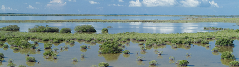
The 1,000-square-mile Florida Bay in Everglades National Park is the southernmost portion of America's Everglades ecosystem and one of the largest seagrass meadows in the world.

Historically, Lake Okeechobee combined with direct rainfall to hydrate the entire Everglades ecosystem, including Florida Bay. In today's managed system, the largest single source of fresh water into Florida Bay is direct rainfall over the bay itself, which accounts for more than 45 percent of its freshwater input. The other major source for freshwater flows into the bay is Taylor Slough in the southeastern part of Everglades National Park.

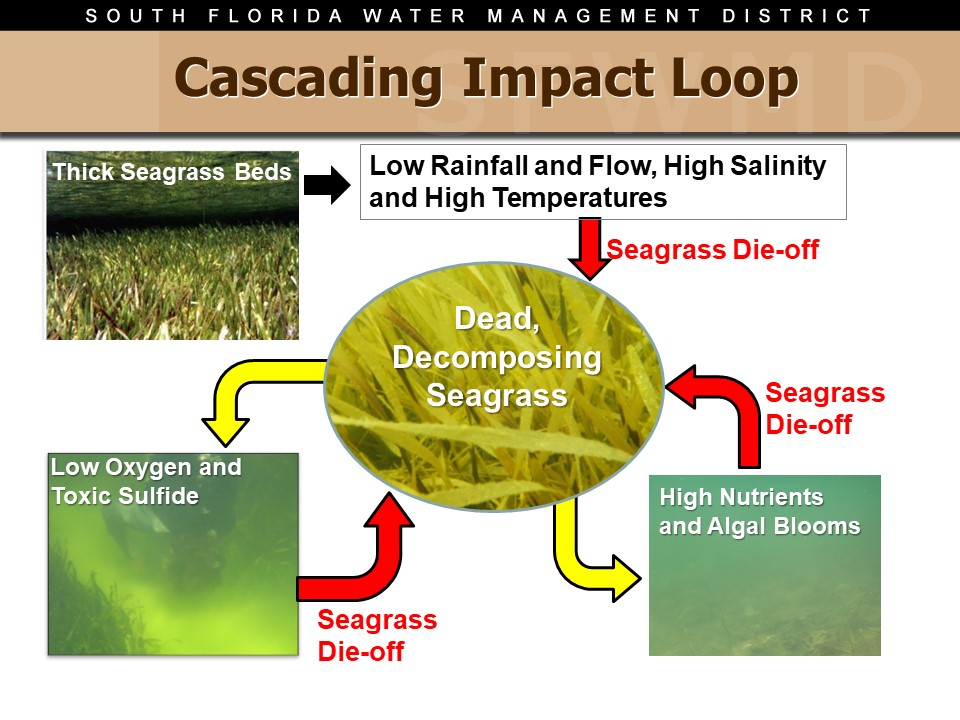
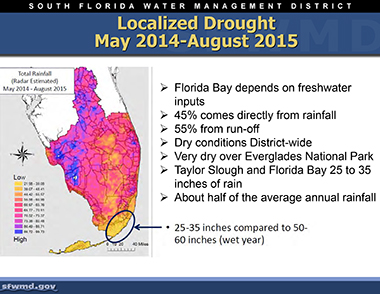
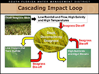
Periodic droughts, such as in 1987 and 2015, have left the waters of Florida Bay too salty, contributing to vast seagrass die-offs that can lead to harmful algal blooms (see the graphic at right). The extreme high salinity in 2015 was the result of a 16-month, localized rainfall deficit. As a result, salinity in parts of Florida Bay was more than twice as high as ocean water.

  • 2018 South Florida Environmental Report (SFER) – The Florida Bay Project: Water Quality Conditions and Status [PDF]
  • 2017 South Florida Environmental Report (SFER) – The Florida Bay Project: Water Quality Conditions and Status [PDF]
  • 2016 South Florida Environmental Report (SFER) – Florida Bay Water Quality Conditions and Status [PDF]
     

Florida Bay News

NEWS RELEASES AND OPERATIONS UPDATES

  • Operations Update: SFWMD Governing Board Takes Action To Help Save Florida Bay – Jan. 12, 2017
  • Operations Update: SFWMD Receives Florida Bay Plan Permit – Sept. 29, 2016 [PDF]
  • Miami-Dade County Resolution Supports SFWMD Plan to Deliver Clean Freshwater to Help Florida Bay – Sept. 21, 2016 [PDF]
  • Multimedia Operations Update: SFWMD Completes Key Component in Plan to Help Save Florida Bay – Aug. 12, 2016 [PDF]
  • Multimedia Operations Update: SFWMD Begins Construction on Plan to Help Save Florida Bay – July 29, 2016 [PDF]
  • Operations Update: Expediting Efforts To Send Water South To Florida Bay – July 25, 2016 [PDF]
  • Operations Update: SFWMD Helps Florida Bay – July 15, 2016 [PDF]
  • Moving Water South Into Florida Bay – July 14, 2016 [PDF]

 
FACT SHEETS AND GET THE FACTS

  • Get the Facts: Helping Save Florida Bay – Jan. 20, 2017
  • Get the Facts: Moving Water to Help Florida Bay – Aug. 31, 2016 [PDF]
  • Get the Facts: SFWMD Plan to Help Florida Bay – July 19, 2016 [PDF]
  • Just the Facts: Moving Water South into Florida Bay [PDF]
  • Get the Facts: Florida Bay – May 11, 2016 [PDF]
×

graphic of Cascading Impact Loop in Florida Bay

Close
thumbnail of map of Florida Bay Plan
Map: The Florida Bay Plan

New Connections for Additional Water Flow to Florida Bay

thumbnail of graphic on localized drought in Florida Bay
Graphic: Localized Drought in Florida Bay

May 2014 to Aug. 2015

thumbnail of Florida Bay plan photo gallery
Photo Gallery and Videos: Florida Bay Plan

Moving Water South to Help Florida Bay

  • ASK US
  • Who We Are
    • Governing Board
    • Big Cypress Basin Board
    • Open Government
    • Public Records Request
  • Our Work
    • Flood Control
    • Resiliency
    • Emergency Management
    • Water Supply Planning
    • Water Quality Improvement
    • Ecosystem Restoration
    • Land Management
  • Community and Residents
    • Water Conservation
    • Year-Round Rule
    • Recreation
    • Educational Center
    • Volunteering
  • Doing Business with Us
    • Permits
    • RegPermitting
    • ePermitting
    • Right of Way Permits
    • Procurement
    • Real Estate
    • Grants/Funding
    • Agriculture
    • AVATAR
  • Science and Information/Data
    • Real-Time Data
    • Water Levels
    • Scientific Publications & SFER
    • DBHYDRO
    • Weather
    • Operational Planning
    • Environmental Monitoring
    • Modeling
  • News and Events
    • News Releases
    • Meeting Agendas & Minutes
    • Calendar
    • Photo and Video Resources
South Florida Water Management District

Contact Information

3301 Gun Club Road
West Palm Beach, FL 33406

561-686-8800

800-432-2045 (Florida Only)

  • Facebook
  • Instagram
  • Twitter
  • Linkedin
  • Youtube
  • ASK US
  • Privacy Policy
  • Disclaimer
  • Accessibility
  • Contact Us
  • Locations
  • Careers