  • Facebook
  • Instagram
  • Twitter
  • Linkedin
  • Youtube
  • ASK US
Home South Florida Water Management District
  • Who We Are
    • Governing Board Chairman
    • Open Government
    • Governing Board
    • Budget & Finance Reports
    • Careers
    • Locations
    • Contact Us
  • Our Work
    • Flood Control
    • Water Supply Planning
    • Water Quality Improvement
    • Ecosystem Restoration
    • Python Elimination Program
    • Addressing Blue-Green Algae
    • Resiliency
  • Doing Business with Us
    • Permits
    • RegPermitting
    • ePermitting
    • Right of Way Permits
    • Procurement
    • Real Estate
    • Grants/Funding Opportunities
  • Community & Residents
    • Water Conservation
    • Recreation
    • Navigation
    • Education Center
    • Everglades License Plate
  • Science & Data
    • Real-Time Data
    • Vertical Datum Upgrade
    • Scientific Publications & SFER
    • DBHYDRO
    • Weather
    • Operational Planning
    • GIS
    • Survey Data
    • Modeling
  • News & Meetings
    • News Releases
    • Public Meetings
    • Calendar
    • Speakers Bureau
    • Media, Photo & Video
    • Fact Sheets
  • Contact Us
  • Careers
  • Locations
  1. Home
  2. our work
  3. caloosahatchee river
  • Flood Control
    • Overview
    • Emergency Management
    • Keeping Canal Right of Way Clear
    • Flood Protection Level of Service
  • Water Supply Planning
    • Overview
    • Upper Kissimmee Basin (CFWI) Plan
    • Lower Kissimmee Basin Plan
    • Upper East Coast Plan
    • Lower East Coast Plan
    • Lower West Coast Plan
    • Alternative Water Supply
    • Water Supply Facilities Work Plans
  • Water Quality Improvement
    • Overview
    • Restoration Strategies
    • Long-Term Plan
    • Everglades Technical Oversight Committee
  • Ecosystem Restoration - By Region
    • Overview
    • Everglades
    • Kissimmee River
    • Lake Okeechobee
    • Coastal Watersheds
    • Florida Bay
  • Ecosystem Restoration - Projects and Programs
    • Advancing Key Priority Projects
    • Biscayne Bay Economic Impact Study
    • CERP Project Planning
    • CERP Funding and Implementation
    • EAA Storage Reservoir Project
    • Feeder Canal Basin Water Quality Program
    • Lake Okeechobee Watershed Restoration Project
    • Lake Okeechobee Component A Reservoir (LOCAR)
    • Lower Kissimmee Basin Stormwater Treatment Area
    • Northern Everglades and Estuaries Protection Program
    • Picayune Strand Restoration Project
    • Water Storage Strategies
  • MFLs & Water Reservations, & RAAs
    • Minimum Flows & Minimum Water Levels
    • Water Reservations
    • Restricted Allocation Areas
  • Land Management
    • Overview
    • Vegetation and Exotic Control
    • Python Elimination Program
    • Land Assessment
  • Local Projects and Programs
    • C-100A Canal Vegetation Removal Project
    • C-15 Canal Vegetation Removal Project
    • Cocohatchee Canal I-75 Loop Interchange Tree Removal Project
    • Corkscrew Watershed Initiative Public Planning Project
    • Flood Protection Around Henderson Creek Canal
    • Lake Belt Mitigation Committee
  • Addressing Blue-Green Algae
  • Resiliency
    • Overview
    • Resiliency and Flood Protection
    • Resiliency and Water Supply
    • Resiliency and Ecosystem Restoration
    • Water and Climate Resilience Metrics
    • Central and Southern Florida Flood Resiliency Study
    • Sea Level Rise and Flood Resiliency Plan
    • Resiliency Coordination Forum
bridge over the Caloosahatchee River

Caloosahatchee River and Estuary

The Caloosahatchee River and Estuary are west coast treasures, enjoyed by residents and visitors alike. Recognizing that the health of the river and its estuary is essential to the overall way of life for area residents, the South Florida Water Management District considers protection and improvement of the Caloosahatchee watershed an agency priority.

Extensive historical modifications to the Caloosahatchee River and its watershed have altered the hydrology of the region. As a result, heavy rainfall can bring large influxes of fresh water into the Caloosahatchee Estuary from stormwater runoff within the basin, Lake Okeechobee releases or both. The increased freshwater flows affect salinity levels and water quality in the estuary, potentially causing environmental harm.

To address these issues, the South Florida Water Management District is working with the U.S. Army Corps of Engineers and other federal, state and local partners on a variety of strategies to improve the health of the Caloosahatchee Estuary.
 

Where is the Latest Data for the Caloosahatchee?

Using SFWMD's monitoring network and technical information, a wealth of data is available on this website for the District's 16-county region, including the Caloosahatchee River and Estuary:

  • Operational Planning – Find weekly operational reports and other information on the current state of the system and water control operations, including water quality and environmental conditions such as salinity levels, Lake Okeechobee water control structure operations recommendations, rainfall outlook models and more.
     
  • Real-Time Data – Check real-time water levels in lakes, canals and waterways or see whether coastal gates and other water control structures are open or closed.
     
  • Rainfall Maps – See maps with historical rainfall totals, current radar-based rainfall estimates and more.
     
  • DBHYDRO – Search this extensive environmental database for historical or up-to-date surface or groundwater information, as well as meteorological, hydrogeological and water quality data.
     

Data and Reports from U.S. Army Corps of Engineers

  • Daily Water Management Reports
  • Lake Okeechobee Report
  • Graphical Report for S-77 (Moore Haven) [PDF]
  • Graphical Report for S-79 (W.P. Franklin) [PDF]


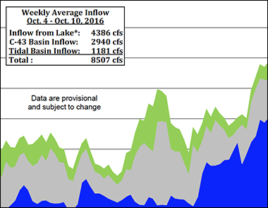
VIEW PREVIOUS CALOOSAHATCHEE ESTUARY INFLOWS »
 

Background / Local Watershed
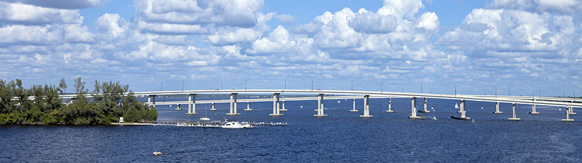
Map of the Caloosahatchee River Watershed - View LargerBeginning in the late 19th century, the Caloosahatchee River and its watershed underwent extensive modifications that drastically altered the hydrology of the region. The once shallow and crooked river was deepened and widened into a regulated waterway that was connected to Lake Okeechobee and the Kissimmee Chain of Lakes for navigation, water supply and flood control purposes.

Caloosahatchee Estuary Inflow Chart
Caloosahatchee Estuary Inflows
  • ASK US
  • Who We Are
    • Governing Board
    • Big Cypress Basin Board
    • Open Government
    • Public Records Request
  • Our Work
    • Flood Control
    • Resiliency
    • Emergency Management
    • Water Supply Planning
    • Water Quality Improvement
    • Ecosystem Restoration
    • Land Management
  • Community and Residents
    • Water Conservation
    • Year-Round Rule
    • Recreation
    • Educational Center
    • Volunteering
  • Doing Business with Us
    • Permits
    • RegPermitting
    • ePermitting
    • Right of Way Permits
    • Procurement
    • Real Estate
    • Grants/Funding
    • Agriculture
    • AVATAR
  • Science and Information/Data
    • Real-Time Data
    • Water Levels
    • Scientific Publications & SFER
    • DBHYDRO
    • Weather
    • Operational Planning
    • Environmental Monitoring
    • Modeling
  • News and Events
    • News Releases
    • Meeting Agendas & Minutes
    • Calendar
    • Photo and Video Resources
South Florida Water Management District

Contact Information

3301 Gun Club Road
West Palm Beach, FL 33406

561-686-8800

800-432-2045 (Florida Only)

  • Facebook
  • Instagram
  • Twitter
  • Linkedin
  • Youtube
  • ASK US
  • Privacy Policy
  • Disclaimer
  • Accessibility
  • Contact Us
  • Locations
  • Careers