Water Depth Assessment Tool (WDAT)
In partnership with SFWMD, hundreds of real-time water level gauges throughout the District’s boundaries are managed by several government agencies, including Everglades National Park, the U.S. Geological Survey and the U.S. Army Corps of Engineers. The Water Depth Assessment Tool (WDAT) is an automated decision support system that provides near-real-time spatial perspectives of water elevation, water depth, water elevation changes, and a series of regulatory and ecological indicators for select District basins and waterbodies where adequate data resources are available.
The WDAT utilizes statistical methods to couple together the multi-agency networks of water level gauges to produce spatially continuous estimates of mean daily surface and surficial ground water elevations for each of the areas listed on the map below. Water depth surfaces are calculated by subtracting known ground elevations (or gridded elevation models) from these water elevation surfaces. Water elevation and water depth information for these areas are the key variables for several ecological and regulatory metrics.
For additional technical information, please see Appendix 1-6 of the 2012 South Florida Environmental Report.
NOTE: All WDAT products are based on provisional data and are subject to review and revision. For more information, contact Jason Godin.
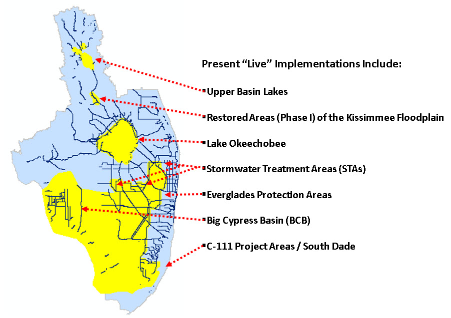
Kissimmee Floodplain (Phases I-II-III)
These areas represent Phases I-II-III of the Kissimmee River restoration project.
Lake Okeechobee
Big Cypress Basin (BCB)
Everglades Protection Areas (EPA)
These areas make up the more than 2.3 million acres consisting of the Florida Everglades as defined by the Everglades Forever Act and adjacent natural areas. This includes the following nine interconnected wetland basins: Water Conservation Areas (WCAs) 1, 2A, 2B, 3A, and 3B and Everglades National Park (ENP); Big Cypress National Preserve (BCNP) / Picayune Strand Complex; and the Holey Land and Rotenberger Wildlife Management Areas (WMAs).
Stormwater Treatment Areas (STAs)
Everglades Stormwater Treatment Areas (STAs)
The Everglades STAs are constructed wetlands that were built to improve the quality of water entering the Everglades system south of Lake Okeechobee.
- STA-1E Animation – daily frames water depth and relevant metrics for past year
- STA-1W Animation – daily frames water depth and relevant metrics for past year
- STA-1W Expansion 2 – daily frames water depth and relevant metrics for past year
- STA-2 – daily frames water depth and relevant metrics for past year
- STA-3/4 – daily frames water depth and relevant metrics for past year
- STA-5/6 – daily frames water depth and relevant metrics for past year
- Everglades STAs Summary Table – stage, depth, and duration statistics by cell
Everglades Agricultural Area A-2 Stormwater Treatment Area (STA)
The Everglades Agricultural Area A-2 STA Stormwater Treatment Area (A-2 STA) is a component of the Central Everglades Planning Project (CEPP). The overall CEPP includes a suite of storage, treatment, conveyance, and seepage management measures that will provide the necessary components to deliver additional fresh water
from Lake Okeechobee south to Water Conservation Area 3, Everglades National Park, and Florida Bay.
- A-2 STA Animation – daily frames water depth and relevant metrics for past year
- A-2 STA Summary Table - stage depth, and duration statistics by cell
Northern Stormwater Treatment Areas (STAs) and Water Preserve Area (WPA)
The Northern STAs are constructed wetlands built to reduce phosphorus loading to Lake Okeechobee and the Everglades. The WPA was built to reduce nutrient loadings and improve the quantity and timing of water deliveries to the North Fork of the St. Lucie River.
- C-44 STA Animation – daily frames water depth and relevant metrics for past year
- Lakeside Ranch STA Animation – daily frames water depth and relevant metrics for past year
- Nubbin Slough STA Animation – daily frames water depth and relevant metrics for past year
- Taylor Creek STA Animation – daily frames water depth and relevant metrics for past year
- Ten Mile Creek WPA Animation – daily frames water depth and relevant metrics for past year
- Northern STAs and WPA Summary Table – stage, depth, and duration statistics by cell