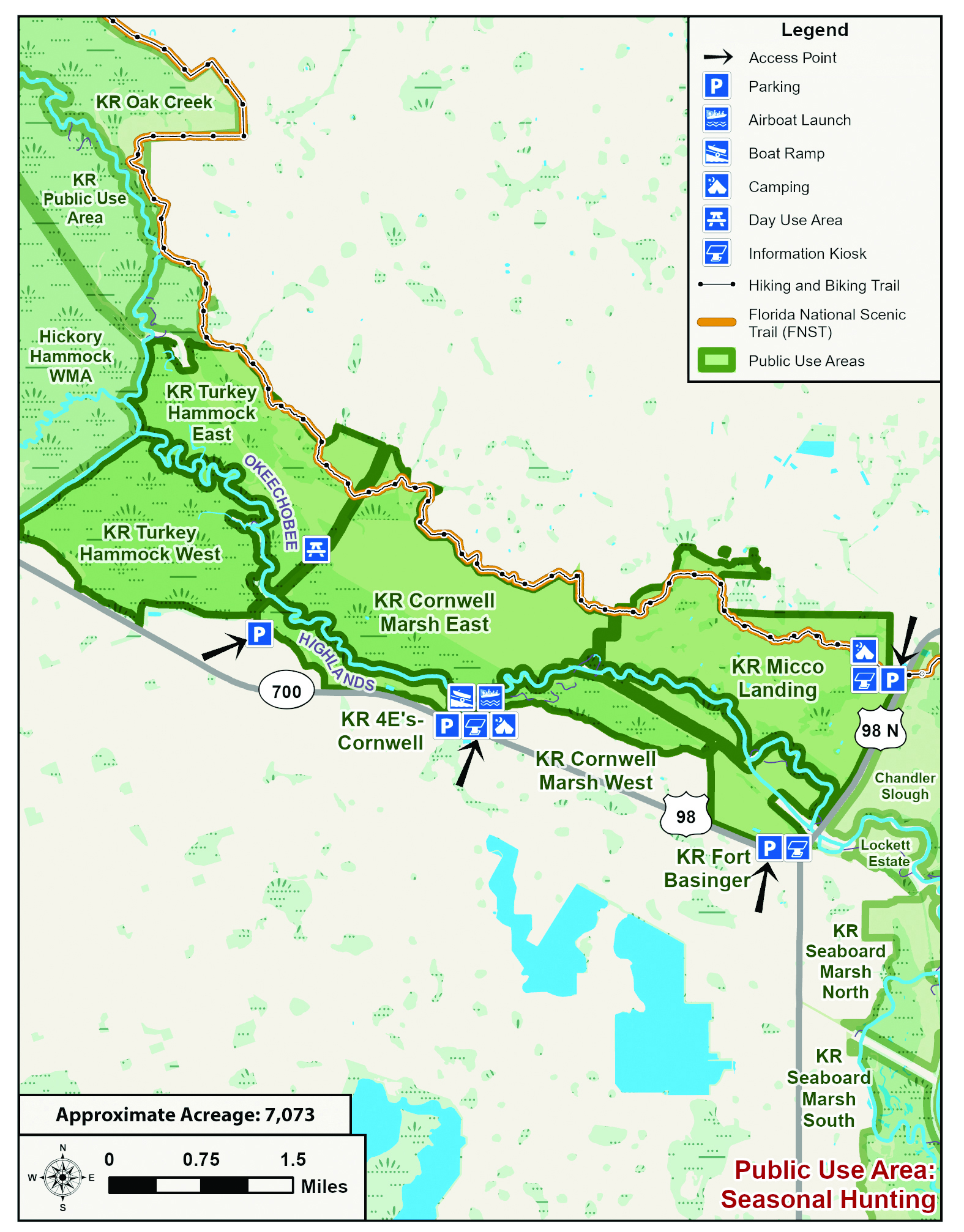
  • ASK US
  • Contact Us
  • Careers
  • Locations
Home South Florida Water Management District
  • Who We Are
    • Governing Board Chairman
    • Open Government
    • Governing Board
    • Budget & Finance Reports
  • Our Work
    • Flood Control
    • Water Supply Planning
    • Water Quality Improvement
    • Ecosystem Restoration
    • Python Elimination Program
    • Resiliency
  • Doing Business with Us
    • Permits
    • Procurement
    • Real Estate
    • Grants/Funding Opportunities
  • Community & Residents
    • Water Conservation
    • Recreation
    • Navigation
    • Education Center
  • Science & Data
    • Real-Time Data
    • Scientific Publications & SFER
    • DBHYDRO
    • Weather
    • Operational Planning
    • GIS
    • Survey Data
    • Modeling
  • News & Meetings
    • News Releases
    • Public Meetings
    • Calendar
    • Photo and Video Resources
    • Fact Sheets
  • Contact Us
  • Careers
  • Locations
  1. Home
  2. Turkey hammock cornwell marsh and micco landing 0
  • Water Conservation
    • Overview
    • How You Can Conserve Water
    • Landscape Irrigation Conservation Measures
    • Florida-Friendly Landscaping
    • Water Use Calculator
  • Recreation
    • Overview
    • Recreation Sites
    • Special Use License (SUL)
    • Navigation
    • Geocaching
  • Education Center
  • What You Can Do
    • Prepare for Flooding
    • Your Impact on the Environment
    • Volunteering
Activities
Airboating
Bicycling
Boating
Camping (Tent)
Canoeing
Equestrian Trails
Fishing
Hiking
Hunting
Kayaking
Picnicking
Stargazing
Turkey Hammock, Cornwell Marsh and MICCO Landing

Turkey Hammock and Cornwell marshes were formally floodplain, converted to pasture. The property now sports a boat ramp, surrounded by grandfather oaks, a cypress dome and cabbage palms. When you push off your boat from the S-65C boat ramp and go left, you'll see a borrow ditch on the south side of Turkey Hammock West. As you view the waterway, your "ugly ditch" perception will be changed. The mile-long ditch resembles a narrow stream, where you'll find almost every local flowering marsh plant along its course.

Pink marsh mallow "hibiscus," purple pickerel weed, yellow primrose, creamy water hemlock and button-bush flowers are on display. Hard-to-spot native water spider orchids, with humble yellowish-purple flowers on smooth, green stalks peek through the thick grasses. Keep your eye out for bonnet worms. They are known as "bonnets" to the locals and make squiggly lines on the spatterdock. The worms are good fish bait.

Airboats are primarily used in the waterway, but consider a canoe or kayak instead. Be sure to flag your boat. Enjoy this spot while you can, as the S-65C lock and access road will be removed in a future river restoration phase, around 2008. Restoration will flood the area, but the river will greatly benefit over all.

The ditch currently flows into the old river. It's an open landscape for most of the way as you head north toward the C-38, but unusually large cypress trees about halfway through make the trek worth the effort. You can also put in at the Istokpoga Canal and come east to this stretch.

Moving south to the Cornwell Marsh, split in half by the C-38, you'll find canoe and kayak access at the 4-E's non-motorized boat ramp off Highway 98. A brown sign marks the entrance. As late as the 1970s, a store, gas pump, cook shack, docks, RV park and bluegrass stage made this a friendly stop on the historic Kissimmee Boat-a-Cade. All that remains are remnant concrete pads and some dock timbers that were originally used as supports for the old wooden bridge across the Kissimmee at Fort Basinger. Today, the most striking asset of this find is a beautiful oak hammock. A short, leaf-littered road serves as an abbreviated, half-mile long nature trail.

The 4-E's entrance and Fort Basinger have been designated by the SFWMD as stargazing sites. Amateur astronomers can gaze at the natural wonders of the heavens from these sites far from bright urban areas.

For More Information:
The management plan for MICCO is under development. Call SFWMD for details: (561) 686-8800, ext. 3022. or Okeechobee Service Center FLWATS 1-800-250-4200.

Activities by Site

  • Cornwell Marsh: fishing, hiking, hunting, stargazing
  • MICCO Landing: airboating, bicycling, boating, camping (tent), canoeing, equestrian trail, fishing, hiking, hunting, kayaking, picnicking, stargazing
  • Turkey Hammock: airboating, boating, canoeing, fishing, hunting, kayaking

Hunting

The Florida Fish and Wildlife Conservation Commission manages hunting on SFWMD lands.
Please visit www.myfwc.com regarding current hunt dates, regulations and directions to check stations to ensure the most accurate and latest information.

Florida's Wildlife Management Areas - Hunting Brochures


Directions

  • Turkey Hammock and Cornwell Marsh: Take Highway 98 north from Okeechobee or east from Sebring. Approximately six miles northwest of Fort Basinger is the S-65C Access Road. Turn right onto the access road and go to the end where a concrete boat ramp is provided for larger boats and an unimproved dirt ramp is available for small boats, canoes, kayaks and airboats. Both of these sites also can be reached by using the unimproved ramp next to the Istokpoga Canal bridge on Highway 98.

Maps and Related Links

Maps

  • Recreation Area Map [PDF]
  • Trail Guide and Map - Micco Landing Management Area [PDF]
  • Micco Landing Trailhead [PDF]
  • Bluff Hammock and Boney Marsh Trailhead [PDF]
  • Fort Basinger Trailhead [PDF]
  • Hickory Hammock Equestrian Center [PDF]
  • Hickory Hammock Hiking Trailhead [PDF]
  • Istokpoga Boat Ramp Area [PDF]
  • Oak Creek Trailhead [PDF]
  • Starvation Slough Trailhead and Airboat Launch [PDF]

Related Links

  • Reference Bird List [PDF]
  • ASK US
  • Who We Are
    • Governing Board
    • Big Cypress Basin Board
    • Open Government
    • Public Records Request
  • Our Work
    • Flood Control
    • Resiliency
    • Emergency Management
    • Water Supply Planning
    • Water Quality Improvement
    • Ecosystem Restoration
    • Land Management
  • Community and Residents
    • Water Conservation
    • Year-Round Rule
    • Recreation
    • Educational Center
    • Volunteering
  • Doing Business with Us
    • Permits
    • ePermitting
    • Procurement
    • Real Estate
    • Cooperative Funding
    • Agriculture
  • Science and Information/Data
    • Real-Time Data
    • Water Levels
    • Scientific Publications & SFER
    • DBHYDRO
    • Weather
    • Operational Planning
    • Environmental Monitoring
    • Modeling
  • News and Events
    • News Releases
    • Meeting Agendas & Minutes
    • Calendar
    • Photo and Video Resources
South Florida Water Management District

Contact Information

3301 Gun Club Road
West Palm Beach, FL 33406

561-686-8800

800-432-2045 (Florida Only)

  • Facebook
  • Instagram
  • Twitter
  • Linkedin
  • Youtube
  • ASK US
  • Privacy Policy
  • Disclaimer
  • Accessibility
  • Login
  • Contact Us
  • Locations
  • Careers