  • Facebook
  • Instagram
  • Twitter
  • Linkedin
  • Youtube
  • ASK US
Home South Florida Water Management District
  • Who We Are
    • Governing Board Chairman
    • Open Government
    • Governing Board
    • Budget & Finance Reports
    • Careers
    • Contact Us
  • Our Work
    • Flood Control
    • Water Supply Planning
    • Water Quality Improvement
    • Ecosystem Restoration
    • Python Elimination Program
    • Addressing Blue-Green Algae
    • Resiliency
  • Doing Business with Us
    • Permits
    • Right of Way Permits
    • Procurement
    • Real Estate
    • Grants/Funding Opportunities
  • Community & Residents
    • Water Conservation
    • Recreation
    • Navigation
    • Education Center
    • Everglades License Plate
  • Science & Data
    • Real-Time Data
    • Scientific Publications & SFER
    • DBHYDRO
    • Weather
    • Operational Planning
    • GIS
    • Survey Data
    • Modeling
  • News & Meetings
    • News Releases
    • Public Meetings
    • Calendar
    • Speakers Bureau
    • Photo & Video
    • Fact Sheets
  • Contact Us
  • Careers
  • Locations
  1. Home
  2. s 65e impoundment and paradise run 0
  • Water Conservation
    • Overview
    • Homeowners
    • Multi-Family Residences and Commercial Buildings
    • Lawn Watering Restrictions
    • Local Government Model Ordinances and Codes
    • District Programs and Partnerships
    • Florida-Friendly Landscaping
    • Water Use Calculator
  • Recreation
    • Overview
    • Recreation Sites
    • Special Use License (SUL)
    • Navigation
    • Geocaching
  • Education Center
  • What You Can Do
    • Prepare for Flooding
    • Your Impact on the Environment
    • Volunteering
    • License Plate
Activities
Airboating
Boating
Canoeing
Fishing
Hunting
Kayaking
S-65E Impoundment and Paradise Run

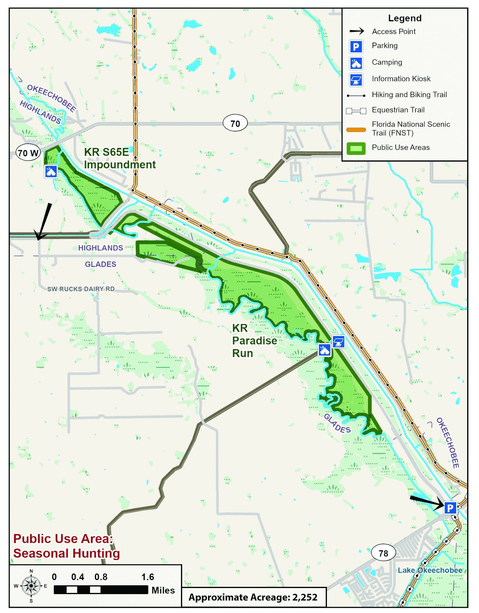
At the end of the old Kissimmee River, on the north side of S-65E, you'll find an expanse of thick marsh that is virtually inaccessible, except for cuts in the old river. The old river resembles the look of the C-38 canal here because it is very wide as it runs through the overgrown marsh. There aren't many places to get out and walk into the impoundment, but the more adventurous might want to park by the marshy pasture at the north end and walk to higher ground to find a shady oak for a picnic. Since this portion of the river is not as heavily visited as others, this would be a good place to canoe or kayak, but bring sunscreen, a hat and water because there is little shade. From a historical perspective, this is a good place to see where the old river dead-ends at a levee to the south. This levee and a canal separate S-65E Impoundment and Paradise Run.

The western border of Paradise Run resembles the edge of a puzzle piece because the old Kissimmee River, with its snaking switchbacks, forms the boundary. Fishing is good in the old river. To the east, toward the C-38, is open, marshy pasture and spoil from the dredging of C-38. This is where the Florida Fish and Wildlife Conservation Commission oversees small game and waterfowl hunts, which are the main attractions for visitors in this area. No airboats are allowed at Paradise Run, but it can be accessed from C-38 by crossing the levee or via the old Kissimmee River from Buckhead Ridge. Among the sites commonly seen at Paradise Run are a large population of burrowing owls, and several bald eagles-both mature and juveniles-who spend their days along Paradise Run.

For More Information:

Send an email to recreation@sfwmd.gov to learn more. 

Activities by Site

  • Paradise Run: bicycling, boating, canoeing, fishing, hiking, hunting, kayaking
  • S-65E: airboating, boating, canoeing, fishing, hunting, kayaking

Directions

  • S-65E Impoundment: Launch from a ramp on the north side of Hwy. 70. From Okeechobee, go west on Hwy. 70. The boat ramp is on the north side of the road immediately after the bridge. This boat ramp is NOT a public ramp and requires a fee. 
  • Paradise Run: Launch from the ramps at Okee-Tantie or Scott Driver boat ramp on the north side of Hwy. 78 at the Kissimmee River. Go upstream toward S-65E, Paradise Run is accessible from C-38 via an old portion of the river entering from the west. From the north you must pass through the S-65E boat lock. Paradise Run is on the right, and signs mark the access sites.

Maps and Related Links

Maps

  • Recreation Area Map [PDF]
  • Paradise Run Trailhead [PDF]
  • ASK US
  • Who We Are
    • Governing Board
    • Big Cypress Basin Board
    • Open Government
    • Public Records Request
  • Our Work
    • Flood Control
    • Resiliency
    • Emergency Management
    • Water Supply Planning
    • Water Quality Improvement
    • Ecosystem Restoration
    • Land Management
  • Community and Residents
    • Water Conservation
    • Year-Round Rule
    • Recreation
    • Educational Center
    • Volunteering
  • Doing Business with Us
    • Permits
    • ePermitting
    • Procurement
    • Real Estate
    • Cooperative Funding
    • Agriculture
    • AVATAR
  • Science and Information/Data
    • Real-Time Data
    • Water Levels
    • Scientific Publications & SFER
    • DBHYDRO
    • Weather
    • Operational Planning
    • Environmental Monitoring
    • Modeling
  • News and Events
    • News Releases
    • Meeting Agendas & Minutes
    • Calendar
    • Photo and Video Resources
South Florida Water Management District

Contact Information

3301 Gun Club Road
West Palm Beach, FL 33406

561-686-8800

800-432-2045 (Florida Only)

  • Facebook
  • Instagram
  • Twitter
  • Linkedin
  • Youtube
  • ASK US
  • Privacy Policy
  • Disclaimer
  • Accessibility
  • Login
  • Contact Us
  • Locations
  • Careers