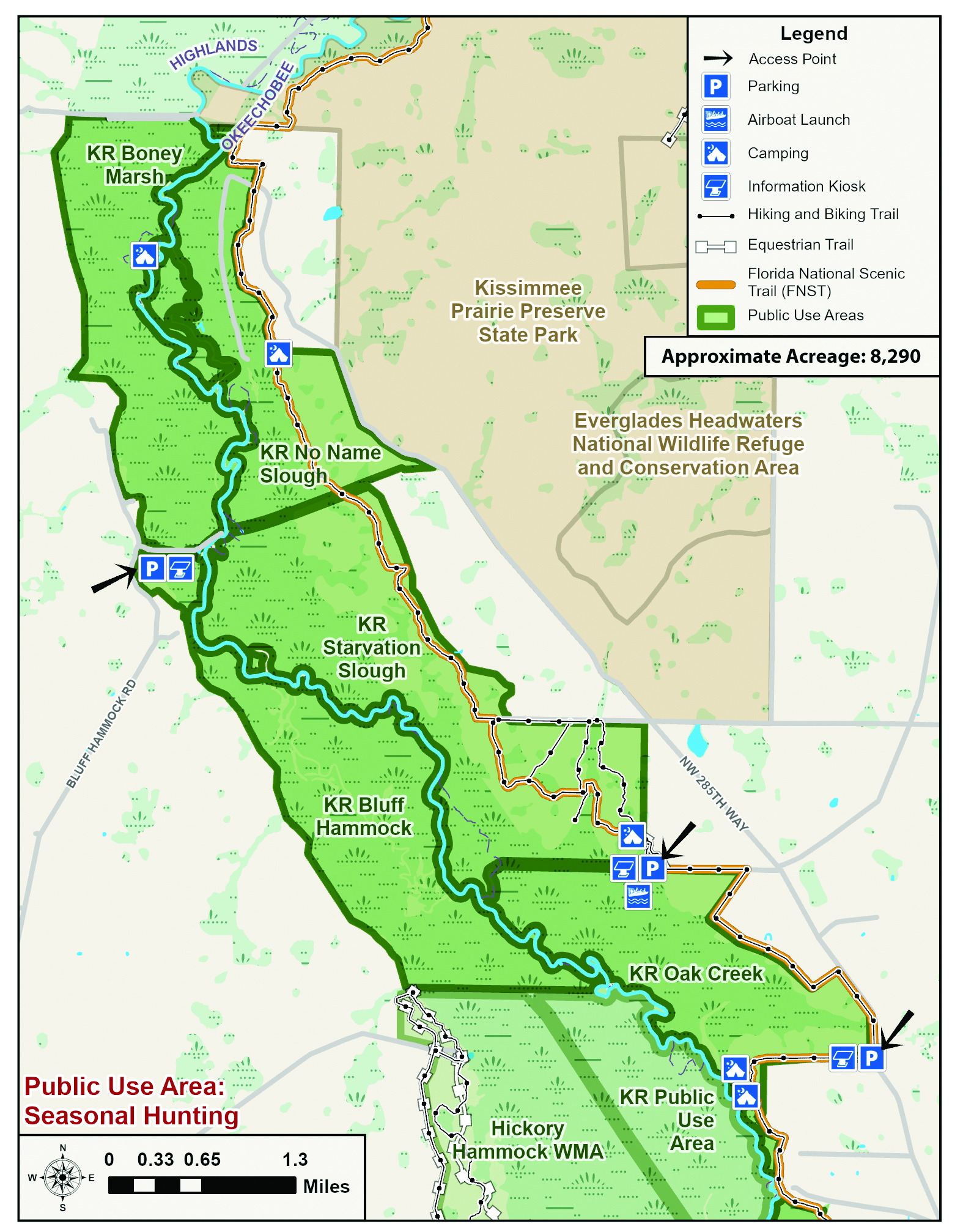
  • Facebook
  • Instagram
  • Twitter
  • Linkedin
  • Youtube
  • ASK US
Home South Florida Water Management District
  • Who We Are
    • Governing Board Chairman
    • Open Government
    • Governing Board
    • Budget & Finance Reports
    • Careers
    • Contact Us
  • Our Work
    • Flood Control
    • Water Supply Planning
    • Water Quality Improvement
    • Ecosystem Restoration
    • Python Elimination Program
    • Addressing Blue-Green Algae
    • Resiliency
  • Doing Business with Us
    • Permits
    • Right of Way Permits
    • Procurement
    • Real Estate
    • Grants/Funding Opportunities
  • Community & Residents
    • Water Conservation
    • Recreation
    • Navigation
    • Education Center
    • Everglades License Plate
  • Science & Data
    • Real-Time Data
    • Scientific Publications & SFER
    • DBHYDRO
    • Weather
    • Operational Planning
    • GIS
    • Survey Data
    • Modeling
  • News & Meetings
    • News Releases
    • Public Meetings
    • Calendar
    • Speakers Bureau
    • Photo & Video
    • Fact Sheets
  • Contact Us
  • Careers
  • Locations
  1. Home
  2. oak creek no name slough and starvation slough management units 1
  • Water Conservation
    • Overview
    • Homeowners
    • Multi-Family Residences and Commercial Buildings
    • Lawn Watering Restrictions
    • Local Government Model Ordinances and Codes
    • District Programs and Partnerships
    • Florida-Friendly Landscaping
    • Water Use Calculator
  • Recreation
    • Overview
    • Recreation Sites
    • Special Use License (SUL)
    • Navigation
    • Geocaching
  • Education Center
  • What You Can Do
    • Prepare for Flooding
    • Your Impact on the Environment
    • Volunteering
    • License Plate
Activities
Airboating
Bicycling
Boating
Camping (Tent)
Canoeing
Camping (Equestrian)
Equestrian Trails
Fishing
Hiking
Kayaking
Picnicking
Stargazing
Wildflower Viewing
Oak Creek, No Name Slough and Starvation Slough Management Units

Oak Creek has many old-growth oaks, some as large as nearly five feet in diameter, along the eastern edge of the Kissimmee River floodplain. Enjoy the shade while you look toward the water's edge. On a spring day, you'll delight in watching butterflies flit about from wildflower to wildflower.

The dominant feature of the property is the creek, with a floodplain that spreads out to join the restored Kissimmee River. Hiking is best during the drier winter months. You'll pass through several bay heads where 20- to 30-foot bay trees grow in the margin of the creek. Use the walkthrough gate at the parking area to get to the picnic tables. Primitive camping is available, and sites have fire rings and picnic tables.

You are permitted to fish in the restored portion of the Kissimmee River. The best access is by airboat, canoe or kayak from the Oak Creek Boat Launch at the north entrance.

The Oak Creek Boat Launch also provides access to Starvation Slough and No Name Slough. If you walk far enough west into the floodplain anywhere along the No Name Slough, you will see the filled portion of the canal. You may ride a horse at both sloughs. An old woods road winds for about three miles through the hammock from the parking area at the north entrance to Oak Creek through Starvation Slough. Riders may take this road though Starvation Slough then continue across the old S-65B tie-back levee along fire breaks into No Name, which continues north for about two miles. Stargazers may also find that Starvation Slough is a good place to set up their telescopes and scan the night sky without interference from bright urban lights.

For More Information:

Send an email to recreation@sfwmd.gov to learn more. 

Activities by Site:

  • No Name Slough: airboating, bicycling, boating, canoeing, equestrian trails, fishing, hiking, hunting, kayaking
  • Oak Creek: airboating, boating, boat ramp, camping (tent), canoeing, fishing, hiking, hunting, kayaking, picnicking
  • Starvation Slough: airboating, bicycling, boating, camping (tent), canoeing, equestrian trails, fishing, hiking, kayaking, picnicking, stargazing, wildflower viewing

Hunting

The Florida Fish and Wildlife Conservation Commission manages hunting on SFWMD lands. 
Please visit www.myfwc.com regarding current hunt dates, regulations and directions to check stations to ensure the most accurate and latest information.

Florida's Wildlife Management Areas - Hunting Brochures


Directions

There are two entrances to Oak Creek (access to Starvation and No Name is from Oak Creek), both on Micco Bluff Road approximately 1.5 miles apart:

  • North entrance, Oak Creek Trailhead and Boat Launch: Access by foot or shallow-drift boat (airboat, canoe or kayak). Parking by boat launch and walk-through gate.
  • South entrance: South of the creek, includes parking and informational kiosk. Walk one mile to picnic area and primitive campsite from parking area.

Micco Bluff Road is off Highway 98 in Ft. Basinger, approximately 28 miles southeast of Sebring, and about 25 miles north of Okeechobee. Turn north on NW 203rd Avenue next to the white block Basinger Community Center. Go to the stop sign and make a left turn onto Micco Bluff Road (160th Street). Veer right at NW 285th Street. The south entrance is 7.5 miles from Highway 98 and the north entrance is about nine miles from Highway 98. Both entrances are on the left.

Maps and Related Links

Maps

  • Recreation Area Map [PDF]
  • Oak Creek Trailhead [PDF]
  • Starvation Slough Trailhead and Airboat Launch [PDF]
  • Bluff Hammock and Boney Marsh Trailhead [PDF]
  • Hickory Hammock Equestrian Center [PDF]
  • Hickory Hammock Hiking Trailhead [PDF]

Related Links

  • Reference Bird List [PDF]
  • ASK US
  • Who We Are
    • Governing Board
    • Big Cypress Basin Board
    • Open Government
    • Public Records Request
  • Our Work
    • Flood Control
    • Resiliency
    • Emergency Management
    • Water Supply Planning
    • Water Quality Improvement
    • Ecosystem Restoration
    • Land Management
  • Community and Residents
    • Water Conservation
    • Year-Round Rule
    • Recreation
    • Educational Center
    • Volunteering
  • Doing Business with Us
    • Permits
    • ePermitting
    • Procurement
    • Real Estate
    • Cooperative Funding
    • Agriculture
    • AVATAR
  • Science and Information/Data
    • Real-Time Data
    • Water Levels
    • Scientific Publications & SFER
    • DBHYDRO
    • Weather
    • Operational Planning
    • Environmental Monitoring
    • Modeling
  • News and Events
    • News Releases
    • Meeting Agendas & Minutes
    • Calendar
    • Photo and Video Resources
South Florida Water Management District

Contact Information

3301 Gun Club Road
West Palm Beach, FL 33406

561-686-8800

800-432-2045 (Florida Only)

  • Facebook
  • Instagram
  • Twitter
  • Linkedin
  • Youtube
  • ASK US
  • Privacy Policy
  • Disclaimer
  • Accessibility
  • Login
  • Contact Us
  • Locations
  • Careers