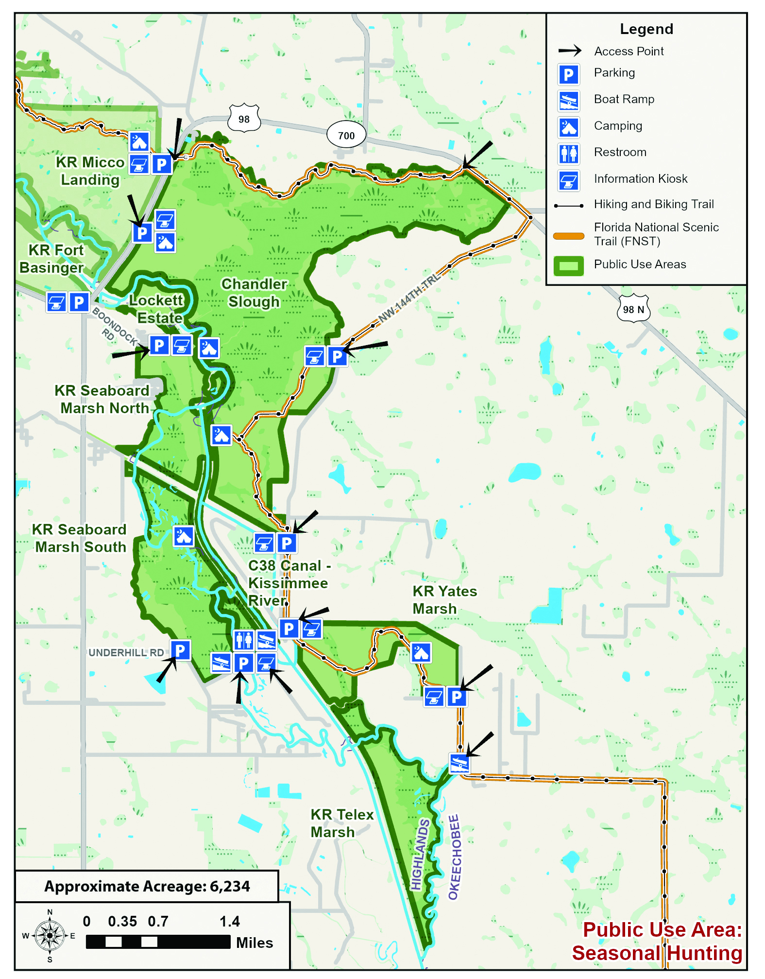
  • Facebook
  • Instagram
  • Twitter
  • Linkedin
  • Youtube
  • ASK US
Home South Florida Water Management District
  • Who We Are
    • Governing Board Chairman
    • Open Government
    • Governing Board
    • Budget & Finance Reports
    • Careers
    • Contact Us
  • Our Work
    • Flood Control
    • Water Supply Planning
    • Water Quality Improvement
    • Ecosystem Restoration
    • Python Elimination Program
    • Addressing Blue-Green Algae
    • Resiliency
  • Doing Business with Us
    • Permits
    • Right of Way Permits
    • Procurement
    • Real Estate
    • Grants/Funding Opportunities
  • Community & Residents
    • Water Conservation
    • Recreation
    • Navigation
    • Education Center
    • Everglades License Plate
  • Science & Data
    • Real-Time Data
    • Scientific Publications & SFER
    • DBHYDRO
    • Weather
    • Operational Planning
    • GIS
    • Survey Data
    • Modeling
  • News & Meetings
    • News Releases
    • Public Meetings
    • Calendar
    • Speakers Bureau
    • Photo & Video
    • Fact Sheets
  • Contact Us
  • Careers
  • Locations
  1. Home
  2. chandler slough
  • Water Conservation
    • Overview
    • Homeowners
    • Multi-Family Residences and Commercial Buildings
    • Lawn Watering Restrictions
    • Local Government Model Ordinances and Codes
    • District Programs and Partnerships
    • Florida-Friendly Landscaping
    • Water Use Calculator
  • Recreation
    • Overview
    • Recreation Sites
    • Special Use License (SUL)
    • Navigation
    • Geocaching
  • Education Center
  • What You Can Do
    • Prepare for Flooding
    • Your Impact on the Environment
    • Volunteering
    • License Plate
Activities
Bicycling
Bird-Watching
Camping (Tent)
Canoeing
Equestrian Trails
Fishing
Hiking
Hunting
Kayaking
Wildlife Viewing
Chandler Slough

Chandler Slough is a beautiful 3,722-acre tract of cypress swamp, oak and cabbage palm hammocks and marsh habitats found about 15 miles north of the town of Okeechobee. This slice of old Florida offers something for everyone. It is a great spot for watching the abundant wildlife, including wading birds and waterfowl, and hikers can also access the Florida Trail which runs through the property.

Armadillo, bobcat, deer, gray squirrels, hogs, opossum, otter, rabbit, raccoon, skunk, turkey, snipe, quail, gopher tortoises, doves, and a variety of wading birds and waterfowl, alligator, fish, and frogs, are among the animals commonly found at Chandler Slough Management Unit. Panthers have also been recorded at Chandler Slough.

Horseback riding, hunting, hiking, bicycling, canoeing, primitive camping at designated sites and fishing are allowed. Campers and horseback riders need to request a no-cost special use permit. For more information see the Licenses and Permits section of this web site.

Hunting

The Florida Fish and Wildlife Conservation Commission manages hunting on SFWMD lands.  
Please visit www.myfwc.com regarding current hunt dates, regulations and directions to check stations to ensure the most accurate and latest information.

Florida's Wildlife Management Areas - Hunting Brochures


Directions

Chandler Slough is accessible by boat from C-38 and the old Kissimmee River run. Chandler Slough has two designated trailheads with parking.

  • The east entrance is a designated parking area on Lofton Road with a walk-through gate. To get there from the town of Okeechobee, travel about 15 miles north on U.S. Highway 98, to Lofton Road. Look for the sign designating "Chandler Slough and Yates Marsh Trailheads". Turn left on Lofton Road and travel about 1.5 miles to the entrance on the west side of the road.
  • The west entrance has a walk-through gate at the designated parking area on U.S. Highway 98, just north of the Kissimmee River bridge in Ft. Basinger. To get there from the south, travel about 18 miles north on U.S. Highway 98 from Okeechobee. The trailhead is on the east side of the highway, about 1.5 miles before the C-38 Canal/ Kissimmee River.

Maps and Related Links

Maps

  • Recreation Area Map [PDF]
  • Chandler Slough Loftin Road Trailhead [PDF]
  • Chandler Slough U.S. 98 Trailhead [PDF]
  • Fort Basinger Trailhead [PDF]
  • Micco Landing Trailhead [PDF]
  • Trail Guide and Map – Chandler Slough Management Unit [PDF]

Related Links

  • Reference Bird List [PDF]
  • ASK US
  • Who We Are
    • Governing Board
    • Big Cypress Basin Board
    • Open Government
    • Public Records Request
  • Our Work
    • Flood Control
    • Resiliency
    • Emergency Management
    • Water Supply Planning
    • Water Quality Improvement
    • Ecosystem Restoration
    • Land Management
  • Community and Residents
    • Water Conservation
    • Year-Round Rule
    • Recreation
    • Educational Center
    • Volunteering
  • Doing Business with Us
    • Permits
    • ePermitting
    • Procurement
    • Real Estate
    • Cooperative Funding
    • Agriculture
    • AVATAR
  • Science and Information/Data
    • Real-Time Data
    • Water Levels
    • Scientific Publications & SFER
    • DBHYDRO
    • Weather
    • Operational Planning
    • Environmental Monitoring
    • Modeling
  • News and Events
    • News Releases
    • Meeting Agendas & Minutes
    • Calendar
    • Photo and Video Resources
South Florida Water Management District

Contact Information

3301 Gun Club Road
West Palm Beach, FL 33406

561-686-8800

800-432-2045 (Florida Only)

  • Facebook
  • Instagram
  • Twitter
  • Linkedin
  • Youtube
  • ASK US
  • Privacy Policy
  • Disclaimer
  • Accessibility
  • Login
  • Contact Us
  • Locations
  • Careers