Skip to main content
Search site
Search
South Florida Water Management District
Toggle navigation
Who We Are
Governing Board Chairman
Open Government
Governing Board
Budget & Finance Reports
Careers
Locations
Contact Us
Our Work
Flood Control
Water Supply Planning
Water Quality Improvement
Ecosystem Restoration
Python Elimination Program
Addressing Blue-Green Algae
Resiliency
Doing Business with Us
Permits
RegPermitting
ePermitting
Right of Way Permits
Procurement
Real Estate
Grants/Funding Opportunities
Community & Residents
Water Conservation
Recreation
Navigation
Education Center
Everglades License Plate
Science & Data
Real-Time Data
Vertical Datum Upgrade
Scientific Publications & SFER
DBHYDRO
Weather
Operational Planning
GIS
Survey Data
Modeling
News & Meetings
News Releases
Public Meetings
Calendar
Speakers Bureau
Photo & Video
Fact Sheets
Contact Us
Careers
Locations
Home
Recreation Sites
Activities
Operator
Is one of
Is all of
Is none of
Is empty (NULL)
Is not empty (NOT NULL)
Airboating
Boardwalk
Fishing Pier
Hunting
Hunting
Parking
Pets Allowed
Photography
Restrooms
Signage/Kiosk
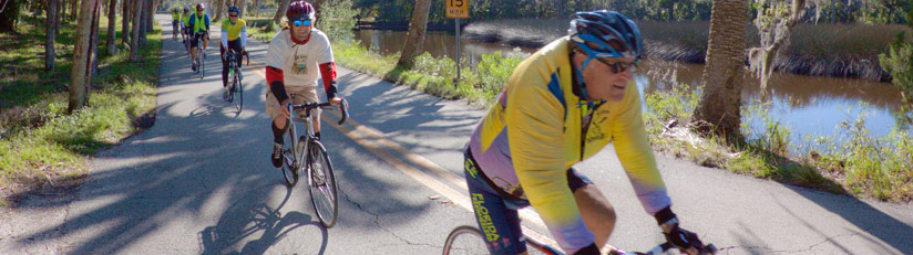
Bicycling
Bird-Watching
Boat Ramps
Boating
Butterfly Garden
Camping (Equestrian)
Camping (Group)
Camping (RV/Travel Trailer)
Camping (Tent)
Canoeing
Education Center
Equestrian Trails
Fishing
Frogging
Geocaching
Hiking
Hunting
Kayaking
Picnicking
Shelter/Pavilion
Stargazing
Swimming
Visitors Center
Wildflower Viewing
Wildlife Viewing
Lookup a Site
Lookup a Site
4E’s
(
#11
)
A-1 Flow Equalization Basin
(
#25
)
Allapattah Flats
(
#18
)
Baker Dairy
(
#3
)
Biscayne Bay Coastal Wetlands
(
#31
)
Blanket Bay Slough
(
#8
)
Bluff Hammock
(
#9
)
Boney Marsh
(
#9
)
C-44 Stormwater Treatment Area
(
#19
)
Catfish Creek
(
#6
)
Chandler Slough
(
#12
)
Corkscrew Regional Ecosystem Watershed (CREW)
(
#28
)
Cornwell Marsh
(
#11
)
Cypress Lake
(
#4
)
Drasdo
(
#6
)
DuPuis Management Area
(
#20
)
East Shore
(
#7
)
Fort Basinger
(
#11
)
Fran Reich Preserve
(
#27
)
Frog Pond
(
#32
)
Gardner-Cobb
(
#4
)
Gordy Road Recreation Area
(
#14
)
Grassy Island
(
#14
)
Green Heart of the Everglades Public Small Game Hunting Area
(
#30
)
Harold A. Campbell Public Small Game Hunting Area
(
#26
)
Hickory Hammock
(
#10
)
Horse Creek
(
#3
)
Huckleberry Island
(
#3
)
Hungryland Wildlife and Environmental Area
(
#21
)
Intercession City
(
#2
)
Istokpoga Canal Boat Ramp Area
(
#10
)
Johnson Island
(
#5
)
KICCO
(
#8
)
Lake Hatchineha and C-37
(
#6
)
Lake Kissimmee Islands
(
#7
)
Lake Marion Creek
(
#3
)
Lakeside Ranch
(
#17
)
Loxahatchee River/Cypress Creek Management Area
(
#22
)
MICCO Landing
(
#11
)
No Name Slough
(
#9
)
Nubbin Slough Stormwater Treatment Area
(
#15
)
Oak Creek
(
#9
)
Paradise Run
(
#13
)
Rocky Glades
(
#32
)
Rolling Meadows
(
#6
)
Rough Island
(
#5
)
S-65D Boat Ramp
(
#12
)
S-65E Impoundment
(
#13
)
Seaboard
(
#12
)
Shingle Creek
(
#1
)
Snell Creek
(
#3
)
Southern Glades
(
#33
)
Starvation Slough
(
#9
)
Stormwater Treatment Area 1 East
(
#24
)
Stormwater Treatment Area 1 West
(
#23
)
Stormwater Treatment Area 3/4
(
#26
)
Stormwater Treatment Area 5/6
(
#23
)
Taylor Creek
(
#14
)
Telex
(
#12
)
Ten Mile Creek
(
#16
)
Torrelli South
(
#3
)
Turkey Hammock
(
#11
)
West Shore
(
#7
)
Yates Marsh
(
#12
)
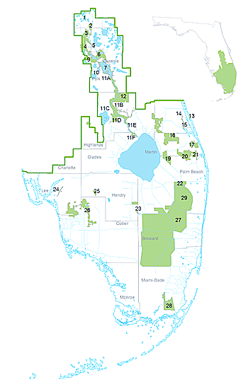
Find Sites
Matching Sites:
4E’s (#11)
4E’s
Take in the beauty of picturesque flowering marsh plants. Pink marsh mallow “hibiscus,” purple…
Allapattah Flats (#18)
Allapattah Flats
Featuring an expanse of predominately wet flatwoods that has mostly been converted to improved…
Baker Dairy (#3)
Baker Dairy
Baker Dairy is part of the Lake Marion Creek Wildlife Management Area which also includes Torrelli…
Biscayne Bay Coastal Wetlands (#31)
Biscayne Bay Coastal Wetlands
Biscayne Bay Coastal Wetlands extends from Culter Bay to the North Homestead area and provides…
Blanket Bay Slough (#8)
Blanket Bay Slough
Blanket Bay Slough offers primitive waterfront camping on the east side of the Kissimmee River.…
Bluff Hammock (#9)
Bluff Hammock
Located along the eastern edge of the Kissimmee River floodplain, Oak Creek has many old-growth…
Boney Marsh (#9)
Boney Marsh
Located along the eastern edge of the Kissimmee River floodplain, Oak Creek has many old-growth…
Catfish Creek (#6)
Catfish Creek
Nestled on the shores of Lake Hatchineha, this area offers many recreational opportunities and…
Chandler Slough (#12)
Chandler Slough
Chandler Slough is a beautiful tract of cypress swamp, oak and cabbage palm hammocks and marsh…
Corkscrew Regional Ecosystem Watershed (CREW) (#28)
Corkscrew Regional Ecosystem Watershed (CREW)
The Corkscrew Regional Ecosystem Watershed (CREW), located in Lee and Collier counties, provides…
Cornwell Marsh (#11)
Cornwell Marsh
Take in the beauty of picturesque flowering marsh plants. Pink marsh mallow “hibiscus,” purple…
Cypress Lake (#4)
Cypress Lake
Cypress Lake is located in the Kissimmee Chain of Lakes watershed, just north of the Gardner-Cobb…
Drasdo (#6)
Drasdo
Nestled on the shores of Lake Hatchineha, this area offers many recreational opportunities and…
DuPuis Management Area (#20)
DuPuis Management Area
Notifications Posted July 24, 2024: A portion of the Powerline Grade in the Dupuis Management…
East Shore (#7)
East Shore
Lake Kissimmee collects water from the upper lakes region, which flows south to the Kissimmee River…
Fort Basinger (#11)
Fort Basinger
Take in the beauty of picturesque flowering marsh plants. Pink marsh mallow “hibiscus,” purple…
Frog Pond (#32)
Frog Pond
The Frog Pond area provide access to the L-31 Canal levees. From the levee, you can access flow…
Gardner-Cobb (#4)
Gardner-Cobb
The Gardner-Cobb Marsh is located in the Kissimmee Chain of Lakes watershed between Cypress Lake,…
Green Heart of the Everglades Public Small Game Hunting Area (#30)
Green Heart of the Everglades Public Small Game Hunting Area
Located in Collier County, Green Heart of the Everglades offers some of the most unique landscapes…
Hickory Hammock (#10)
Hickory Hammock
Majestic live oaks line both sides of the hiking trail as you enter Hickory Hammock. Marshes,…
Horse Creek (#3)
Horse Creek
Horse Creek is part of the Lake Marion Creek Wildlife Management Area which also includes Torrelli…
Huckleberry Island (#3)
Huckleberry Island
Huckleberry Island is part of the Lake Marion Creek Wildlife Management Area which also includes…
Hungryland Wildlife and Environmental Area (#21)
Hungryland Wildlife and Environmental Area
Outdoor enthusiasts can take advantage of several miles of established, multi-use trails for hiking…
Istokpoga Canal Boat Ramp Area (#10)
Istokpoga Canal Boat Ramp Area
The Istokpoga Canal Boat Ramp Area features boat ramps and an airboat ramp. It also has access to…
Johnson Island (#5)
Johnson Island
Located in the Reedy Creek watershed, this area features picturesque views amid a mosaic of…
KICCO (#8)
KICCO
KICCO Wildlife Management Area, which is pronounced kiss-oh, is a place where you can get the real…
Lake Kissimmee Islands (#7)
Lake Kissimmee Islands
Lake Kissimmee collects water from the upper lakes region, which flows south to the Kissimmee River…
Lake Marion Creek (#3)
Lake Marion Creek
Lake Marion is part of the Lake Marion Creek Wildlife Management Area which also includes Torrelli…
MICCO Landing (#11)
MICCO Landing
Take in the beauty of picturesque flowering marsh plants. Pink marsh mallow “hibiscus,” purple…
No Name Slough (#9)
No Name Slough
Located along the eastern edge of the Kissimmee River floodplain, the Starvation Slough Airboat…
Oak Creek (#9)
Oak Creek
Located along the eastern edge of the Kissimmee River floodplain, Oak Creek has many old-growth…
Paradise Run (#13)
Paradise Run
At the end of the old Kissimmee River, on the north side of S-65E, you’ll find an expanse of thick…
Rocky Glades (#32)
Rocky Glades
The Rocky Glades area provide access to the L-31 Canal levees. From the levee, you can access flow…
Rolling Meadows (#6)
Rolling Meadows
Nestled on the shores of Lake Hatchineha, this area offers many recreational opportunities and…
Rough Island (#5)
Rough Island
Located in the Reedy Creek watershed, this area features picturesque views amid a mosaic of…
S-65D Boat Ramp (#12)
S-65D Boat Ramp
Chandler Slough is a beautiful tract of cypress swamp, oak and cabbage palm hammocks and marsh…
S-65E Impoundment (#13)
S-65E Impoundment
At the end of the old Kissimmee River, on the north side of S-65E, you’ll find an expanse of thick…
Seaboard (#12)
Seaboard
Chandler Slough is a beautiful tract of cypress swamp, oak and cabbage palm hammocks and marsh…
Snell Creek (#3)
Snell Creek
Snell Creek is part of the Lake Marion Creek Wildlife Management Area which also includes Torrelli…
Southern Glades (#33)
Southern Glades
This area offers miles of hiking and bicycling trails and accessible fishing platforms within an…
Starvation Slough (#9)
Starvation Slough
Located along the eastern edge of the Kissimmee River floodplain, the Starvation Slough Airboat…
Telex (#12)
Telex
Chandler Slough is a beautiful tract of cypress swamp, oak and cabbage palm hammocks and marsh…
Torrelli South (#3)
Torrelli South
Torrelli South is part of the Lake Marion Creek Wildlife Management Area which also includes Horse…
Turkey Hammock (#11)
Turkey Hammock
Take in the beauty of picturesque flowering marsh plants. Pink marsh mallow “hibiscus,” purple…
West Shore (#7)
West Shore
Lake Kissimmee collects water from the upper lakes region, which flows south to the Kissimmee River…
Yates Marsh (#12)
Yates Marsh
Chandler Slough is a beautiful tract of cypress swamp, oak and cabbage palm hammocks and marsh…
Site Locations: