  • Facebook
  • Instagram
  • Twitter
  • Linkedin
  • Youtube
  • ASK US
Home South Florida Water Management District
  • Who We Are
    • Governing Board Chairman
    • Open Government
    • Governing Board
    • Budget & Finance Reports
    • Careers
    • Locations
    • Contact Us
  • Our Work
    • Flood Control
    • Water Supply Planning
    • Water Quality Improvement
    • Ecosystem Restoration
    • Python Elimination Program
    • Addressing Blue-Green Algae
    • Resiliency
  • Doing Business with Us
    • Permits
    • RegPermitting
    • ePermitting
    • Right of Way Permits
    • Procurement
    • Real Estate
    • Grants/Funding Opportunities
  • Community & Residents
    • Water Conservation
    • Recreation
    • Navigation
    • Education Center
    • Everglades License Plate
  • Science & Data
    • Real-Time Data
    • Vertical Datum Upgrade
    • Scientific Publications & SFER
    • DBHYDRO
    • Weather
    • Operational Planning
    • GIS
    • Survey Data
    • Modeling
  • News & Meetings
    • News Releases
    • Public Meetings
    • Calendar
    • Speakers Bureau
    • Media, Photo & Video
    • Fact Sheets
  • Contact Us
  • Careers
  • Locations
  1. Home
  2. news
  3. closing north shore navigation locks lake o levels continue drop
  • News Releases
  • News Archive (Oct. 2009 - July 2020)
  • Fact Sheets
  • Calendar
  • Speakers Bureau
  • Media, Photo & Video
  • Public Meetings and Forums
Closing North Shore Navigation Locks as Lake O. Levels Continue to Drop
map of north shore locks
West Palm Beach, FL - For boaters navigating to and from Lake Okeechobee, the South Florida Water Management District (SFWMD) will close several navigation locks on the north shore and reduce the operating hours of a fifth lock for safety reasons starting Friday, March 29. The closures are a result of lower water levels in Lake Okeechobee. Injury and lock damage could occur when boats pass through these structures at water levels below any of the designated safety limits.
 
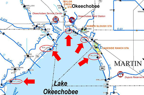
Today, the water level in Lake Okeechobee is 11.97 feet NGVD. The following north shore locks are required to close for safety reasons when the lake falls below 12 feet NGVD:
  • Martin County: S-135 structure, J&S Fish Camp
  • Okeechobee County: G-36 structure, Henry Creek
  • Glades County: S-127 structure, Buckhead Ridge
  • Glades County: S-131 structure, Lakeport

>>MORE

  • ASK US
  • Who We Are
    • Governing Board
    • Big Cypress Basin Board
    • Open Government
    • Public Records Request
  • Our Work
    • Flood Control
    • Resiliency
    • Emergency Management
    • Water Supply Planning
    • Water Quality Improvement
    • Ecosystem Restoration
    • Land Management
  • Community and Residents
    • Water Conservation
    • Year-Round Rule
    • Recreation
    • Educational Center
    • Volunteering
  • Doing Business with Us
    • Permits
    • RegPermitting
    • ePermitting
    • Right of Way Permits
    • Procurement
    • Real Estate
    • Grants/Funding
    • Agriculture
    • AVATAR
  • Science and Information/Data
    • Real-Time Data
    • Water Levels
    • Scientific Publications & SFER
    • DBHYDRO
    • Weather
    • Operational Planning
    • Environmental Monitoring
    • Modeling
  • News and Events
    • News Releases
    • Meeting Agendas & Minutes
    • Calendar
    • Photo and Video Resources
South Florida Water Management District

Contact Information

3301 Gun Club Road
West Palm Beach, FL 33406

561-686-8800

800-432-2045 (Florida Only)

  • Facebook
  • Instagram
  • Twitter
  • Linkedin
  • Youtube
  • ASK US
  • Privacy Policy
  • Disclaimer
  • Accessibility
  • Contact Us
  • Locations
  • Careers